How To Measure Distance on Google Maps (Desktop and Mobile)

Google Maps already tells you the distance to your destination. However, did you know you can also measure the distance between two points on Google Maps? Yes, you can measure distance on Google Maps in any direction over any terrain. This can be particularly useful for measuring hiking trails and other non-official paths that Google Maps can’t create a path on so it won’t show distance too.

If you are interested in calculating the distance between two or more points, then keep reading and I’ll show you how to measure distance on Google Maps on desktop and mobile apps.

Measure distance on Google Maps desktop

It’s easy to measure distance on Google Maps desktop version, but make sure Google Maps lite version is not enabled as this feature isn’t available on it. If there is a bolt icon at the bottom, then it means the lite version is enabled and you should disable it. Follow the below instructions afterward:

Zoom in on the location till you can comfortably see the starting point. Now right-click on the starting point and select “Measure distance” from the context menu. This will drop a starting point.

Measure distance on Google Maps desktop

Afterward, left-click anywhere to drop the next point. Google Maps will draw a line between the two points and show the total difference in meters and feet or kilometers and miles at the bottom.

Distance measure

You can keep left-clicking to add as many points as you like and the distance will be calculated by Google Maps.

add multiple points

You can left-click on an already added point to remove it. The added points are also draggable, so you can adjust the path as you please after creating it.

adjust points

When you are done measuring distance, right-click anywhere and select “Clear measurements” to remove all the points.
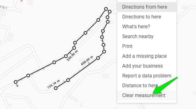
Clear mesurements

Measure distance on Google Maps mobile app

Measuring distance on Google Maps Android or iOS app is a bit different as it uses a dragging method instead of just adding two points. However, I would say it’s much easier to use and more precise as well. Here’s how to use it:

Tap and hold on the starting point to drop a pin. An information card will open at the bottom. Tap on the card (on white space) to open it and select the “Measure distance” option.

Measure distance on Google Maps Android app

A point will be dropped at the pin location and another draggable point will appear with a line drawn between both points. You can move around the point to drag it to the location where you want the second point. And then tap on the blue “Add point” button to add the second point.

You can continue adding points as much as you like and the distance will be calculated at the bottom left side of the screen. The measuring unit depends on your current measuring unit preference in Google Maps settings.

Measured distance on Google Maps Android app

Unfortunately, there aren’t many customization options on the mobile app. The best you can do is undo wrong changes and clear all the added points. There is no option to adjust added points or even remove them individually.

Use a third-party tool to measure distance on Google Maps

Although Google Maps built-in feature to measure distance works fine but if you want more features and customizations, then a third-party tool will work better. There are many Google Maps distance calculator tools, but I personally found DaftLogic to be most intuitive and it also free; so I’ll recommend it.

Open up DaftLogic Google Maps Distance Calculator and at the top, you have multiple methods to search for the location. This includes text search, ZIP code, Latitude and Longitude, and your current location. Use any of these methods to move to the location you would like to measure.

Find location on DaftLogic

The measuring tool works the same as the one in Google Maps. Just left-click to drop a point and click again to drop a second point, the distance between two points will be calculated below. You can also add multiple points to create a path.
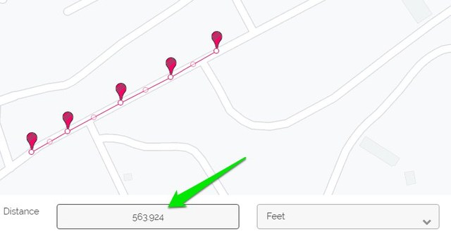
Distance measured on daftlogic

You can also select measuring units, including feet, meters, kilometers, miles, and nautical miles.

Select measure unit on DaftLogic

There are also a bunch of more handy options such as Zoom to fit to auto zoom on the path created, toggle markers on/off for visibility, and the ability to print the marked map.

Compared to Google Maps, DaftLogic also has thinner marking tools which make adding points easier. It also automatically adds another movable point between each point that you can use to move the line for more precise measuring.

Overall, if you need to measure distance on Google Maps on a regular basis, then DaftLogic will be a much better tool.

To conclude

So this is how you can measure distance on Google Maps anywhere in the world in any direction. If you need to measure distance frequently, then I will recommend you to do it on the PC as it provides much more control. If you have any further questions, do let us know in the comments below.

The post How To Measure Distance on Google Maps (Desktop and Mobile) appeared first on Gtricks.


via Gtricks https://ift.tt/33olT2c

[Fix] Can’t Unmaximize or Restore Down Programs in Windows 10

https://ift.tt/eA8V8J Recently an AskVG reader contacted me regarding this weird and annoying issue encountered in Windows 10. He upgraded his computer from...

Read the full article at AskVG.com

via AskVG https://ift.tt/39UJZEn

[Review] Which DTH Service Provides Maximum HD Channels in India?

https://ift.tt/eA8V8J UPDATED on March 14, 2020: Addition of D SPORT HD channel on Sun Direct. Ever since we posted our exclusive reviews...

Read the full article at AskVG.com

via AskVG https://ift.tt/2r22Lrs

[Tip] Disable Security Questions Requirement for Local User Accounts in Windows 10

https://ift.tt/eA8V8J In newer versions of Windows 10 operating system, when you try to create a new local user account, you are required...

Read the full article at AskVG.com

via AskVG https://ift.tt/2Wj0Lc6

[Firefox Tip] Disable Tabs Drag-n-Drop Feature to Move to New Window

https://ift.tt/eA8V8J This article will help you in disabling or removing tab detaching or tab tearing feature in Mozilla Firefox web browser which...

Read the full article at AskVG.com

via AskVG https://ift.tt/2TVdYoW

Tell Google Maps Your Taste Preference For Better Restaurant Recommendations

Google Maps isn’t just your navigation buddy, it’s your guide to explore everything around you. Particularly talking about restaurant recommendations, Google Maps does an amazing job of helping you find the best places to eat with sufficient information to make the right choice. If you are using Google Maps for finding food joints around you, then it’s a good idea to let Google Maps know what type of food you like.

You can tell Google Maps your taste preference and the next time you will search for restaurants near you, it will consider your taste preference while listing the restaurants. If you like this idea, then let’s see how to add your taste preference in Google Maps.

Tell Google Maps your food and drink preferences

You can tell Google Maps both what you like and dislike in food, and you can make these changes right inside Google Maps settings. Here’s how:

In the Google Maps mobile app, tap on the main menu at the top-left corner and select the “Settings” option from it.

Google Maps Settings

Now scroll down and click on “Exploring places” and then click on “Food & drink preferences”.

Exploring places

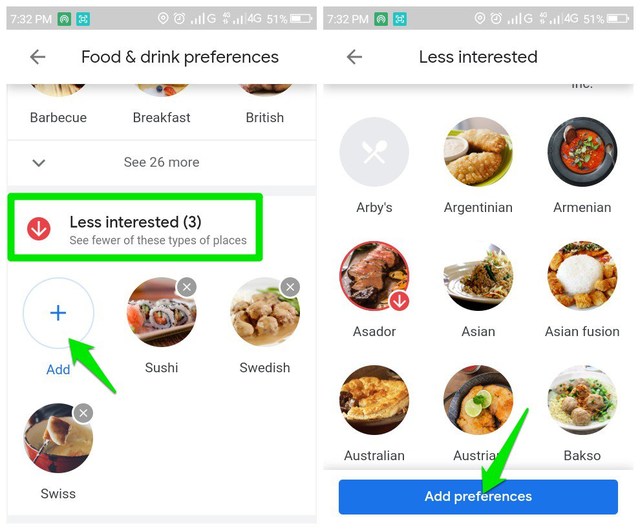
Here you can provide your dietary preferences, the food you are interested in and the food you are less interested in.

In the dietary preferences, you can limit your food choices, such as only halal, vegetarian, kosher, and Gluten-free, etc.

Tap on the “Add” button in the “Interested” section and Google Maps will list all food types arranged in alphabetical order. You can tap on each food type to select it, and you can select as many as you like. Once you are done selecting, click on the “Add preferences” button below to add them.

Food you are interested in

The “Less Interested” section works the same way. Just tap on “Add” here and it will list all the food types from which you can select the ones you are less interested in.

Food you are less interested in

That’s it, now the results you will see while making any search related to food and restaurants will be personalized to your taste.

Ending thoughts

I have personally experimented with this feature by mentioning up to 25 of my favorite food types. For the same search query, the results were astonishingly different. The restaurants listed when I mentioned my preference were very accurate to my taste and each one of them made me stop and look. On the other hand, when I tried the same query without telling my preferences, the results were vague and I skipped most of the restaurants as they didn’t appeal to me at all. So I can safely say, this feature is definitely doing its job.

The post Tell Google Maps Your Taste Preference For Better Restaurant Recommendations appeared first on Gtricks.


via Gtricks https://ift.tt/38EociP

How To Add Your Home And Work Address in Google Maps

Adding your home and work address can greatly enhance your Google Maps experience. Basically, Google uses this information to provide a personalized experience. For example, Google can recommend restaurants based on your home location. It can also automatically tell you about traffic conditions from your home to work commute and vice versa.

Your work and the home location are also only visible to you, the data is hidden from the public. If you are ready to add these details in your Google Maps app, I’ll show you how.

Note: Google can also use this information to show personalized ads, so you may prefer to avoid providing this information if you are uncomfortable with this practice.

Add your home and work address in Google Maps

Your work and home address can be added from the Google Maps settings, just follow the below instructions:

In the Google Maps app, tap on the Main Menu at the top-left corner and select “Your places” option from it.

Your Places Google Maps

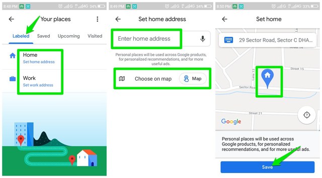
Here, under the “Labeled” tab, you will find fields to add both home and work addresses. Tap on “Home” here.

On the next page, you can add the home address by searching for it on the search bar or choosing it on the map. For most users, finding the location on the map will be much easier. Just use your preferred method and choose your home address.

Add home address in Google Maps

Afterward, you can tap on “Set up your commute” to add your work address as well, or tap on “Skip” if you only want to add your home address.

Set up your commute

For the work address, you will have the same options to add a work address using the search bar or choose it on the map. Use any of the options to add the address.

You can also add more information such as your commute method and commute time to further personalize your experience. If you want to add this information as well, then tap “Next” and provide it.

Add work address in Google Maps

That’s it, your home and work address will be added and you will receive a personalized experience based on your home, work, and current location.

Ending words

I personally find the most impact of this feature while finding a route to my home as it automatically recommends me the best route to home. Also, the instructions I have provided is for the Google Maps Android app, same instructions can be used for the Google Maps web app as well. If you have any questions, do let us know in the comments below.

The post How To Add Your Home And Work Address in Google Maps appeared first on Gtricks.


via Gtricks https://ift.tt/38y2c9b

[Changelog] What’s New in Microsoft Edge 130 and Later Versions

UPDATE: Addition of Microsoft Edge 132.0 version. In this exclusive changelog article, we are providing information about all versions of Mi...