Previously, I showed you guys how to measure distance on Google Maps in any direction. However, did you know you can also use the same tool to measure an area as well? Yes, if you want to measure a land piece, you don’t need to hire any professionals to get an estimate measure. Google Maps can help you measure land pieces of any shape in square feet and square meters.
Of course, the measurement would not be as precise as physical measurement, but it will be accurate enough to give an estimated size of any land to flourish a discussion. Let’s see how you can measure an area on Google Maps.
Measure an area on Google Maps
Unlike measuring distance, measuring an area isn’t possible on the Google Maps mobile apps. You will have to use the Google Maps desktop version to measure an area. Here’s how:
Tip: For precision, it is better to switch Google Maps to “Satellite mode” as you will be able to see the actual form of the land.
Zoom in on the land or property you would like to measure until you can properly see to draw a boundary (the closer, the better). Now right-click at a corner of the property and select the “Measure distance” option to drop a starting point.

You can use left-click to drop more points in order to create a boundary. You must fully create a boundary using these points until you reach the starting point again and click on it. As soon as a full boundary is created, the land size in square feet and the square meters will be shown below.

For precision, you should drop lots of points to cover every curve in the land. The shape of the land doesn’t matter as long as you drop enough points to create a perfect boundary. Below is an image of using lots of points to measure the land precisely.
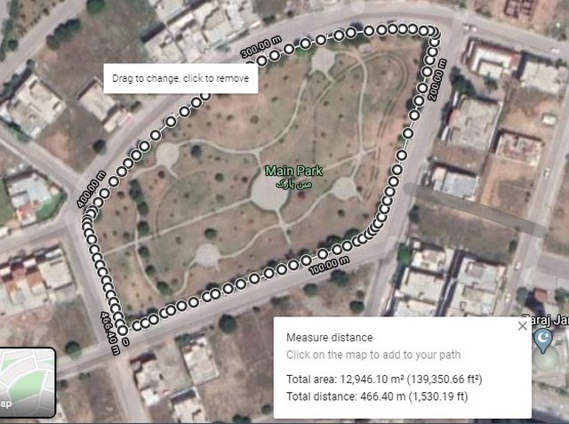
Each point is also draggable, so you can adjust dropped points for further precision if needed. To remove a point, just left-click on it and it will be removed.
Measure an area on Google Maps using a third-party tool
If you need to measure areas on Google Maps often, then I will recommend you to use a third-party tool instead. Google Maps built-in area calculator is rather limited in features. For example, it’s limited to showing measurement in square footage and square meters only, what if you need to measure in acres on Google Maps? This is where a third-party tool will help you.
Although there are many area calculator tools for Google Maps, but I’ll recommend DaftLogic Area Calculator for the ease of use and it is completely free.
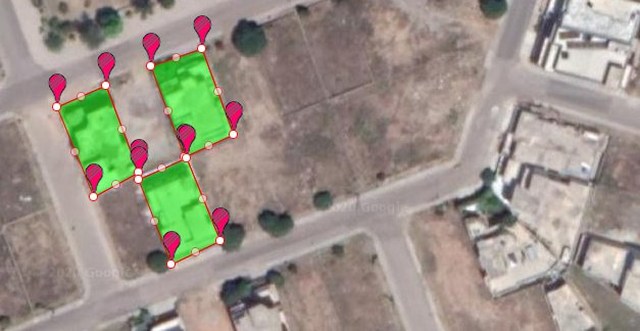
Open up DaftLogic Google Maps Area Calculator and at the top provide the required location using multiple methods, including text search, ZIP code, UK Postcode, GPS coordinates, and current location.

Now left-click on a corner of the land to drop a pin and continue dropping pins to create a boundary. The map will automatically fill the area with color to make it easier to distinguish the area selected. The line and fill color, both can be changed if needed.

Once an outline of the land is drawn, DaftLogic will show its size at the bottom in square feet, square meter, acres, hectares, square miles, and square kilometer.

Using the tool is similar to Google Maps’ built-in tool. You left-click to place a point and right-click to remove one. Each point is draggable to adjust as needed, and you can toggle markers on/off for better visibility.
You can also use the “Create New Area” option at the bottom to measure multiple areas on the map at the same time.
Overall, DaftLogic gives much more control over measuring areas on Google Maps and it offers measurement in the most needed measuring units as well.
Wrapping up
If you are in the real estate business, then you will surely find this feature of Google Maps very useful. It surely isn’t foot-by-foot precise, but if you need to quickly give an estimated measurement of a property, then it’s perfect. Do let us know in the comments if you found this feature useful.
The post 2 Methods To Measure an Area on Google Maps appeared first on Gtricks.


via Gtricks https://ift.tt/38WSI7D
No comments:
Post a Comment
If you have any question please let me know